.JPG)
Discover Bilaspur
Bilaspur is a city located in Bilaspur District in the Indian state of Chhattisgarh. Bilaspur is the Administrative headquarters of the Bilaspur District and Bilaspur Division. The Chhattisgarh High Court, located at Bodri, District Bilaspur has privileged it with the title Nyayadhani (Law Capital) of the State. This city is the commercial center and business hub of North East Chhattisgarh region.
Bilaspur is also an important city for the Indian Railways, as it is the headquarters for South East Central Railway Zone (SECR) and the Bilaspur Railway Division. Bilaspur is also the headquarters of South Eastern Coalfields Limited. Chhattisgarh's biggest power plant operated by NTPC is in Sipat. PowerGrid in Sipat pools electricity from other power plants in region and transmits electricity to Delhi via one of longest HVDC line.
Historically, Bilaspur was part of Dakshina Kosala and was near capital of Malhar, Chhattisgarh (ancient Mallar), Sirpur (ancient Shripura), Tuman (ancient Tummana), and Ratanpur (ancient Ratnapura). From the 5th century onwards it was controlled by the Kalachuri dynasty of Ratanpur. Ratanpur was historical capital of Chhattisgarh state for many different dynasty. Bilaspur city, however, came into prominence around 1741, the year of the Maratha Empire rule, when a Maratha official took up his abode there to control dynasty of Ratanpur.
The management of Bilaspur district was taken over by the British East India Company in 1818 after Bhosale lost territory in Third Anglo-Maratha War. Under Bhosale of the Nagpur kingdom there were many subedars or zamindars/landlords like Akbar Khan, Vazeer Khan, Sao and others in Bilaspur.
Bilaspur district was constituted in 1861, followed by Bilaspur municipality in 1867.[5] Famines in the Bilaspur district were recorded by the British administration in 1828–9, 1834–5, 1845–6, 1868–9 and 1899–1900. In 1868-9 and 1899–1900, the rains failed almost completely, resulting in severe distress, migration and desertion of villages. After the 1868-9 famine there was prosperity for the next 25 years.
Guru Ghasidas (1756–1836) started a religious movement, Satnamis (meaning the worshippers of Satnam(not related to Sikhism), between 1820 and 1830 primarily around the Sonakhan forests. This religious movement preached against idol-worship, and instead stressed that God is synonymous with truth. His community was a farming community. The university at Bilaspur is named after him as Guru Ghasidas University.
Railways arrived at Bilaspur in the decade 1880–90, with the arrival of the Bengal Nagpur Railway. In 1888 laid the first railway tracks from Rajnandgaon to Bilaspur, and in that same year built the line from Bilaspur to Jharsuguda, including the bridge over the Champa river. In 1890, the present railway station and yard were constructed.
In 1901, the population of Bilaspur was 18,937 and it was the eighth-largest town in the Central Provinces of British India. In 1908, weaving of tasar silk and cotton clothes were recorded as the major industries of Bilaspur.
Historical records like Imperial Gazetteer of India, Vol 8, 1908 note that the city is said to be named after a fisherwoman by the name of "Bilasa" in the 17th century, and for a long period it consisted only of a few fishermen's huts. Another book like [The highlands of central India, James Forsyth, 1889] states that Bilaspur is named after 'Palash' tree butea frondosa which are found in abundance in the area. In Sanskrit Bilas means playful or enjoyment and Pur means city or town. So, literally Bilaspur mean the city of enjoyment.
Bilaspur is located at 22.09°N 82.15°E.[6] It has an average elevation of 264 metres (866 ft).
Bilaspur is situated on the banks of the rain-fed Arpa River, which originates from the Maikal Range of Central India. It's a dolomite rich region surrounded by dense forests in the north and the coal mines of the Hasdeo Valley in the east.
Bilaspur District is surrounded by Gaurella-Pendra-Marwahi District in the north, Anuppur District of Madhya Pradesh, Mungeli and, Baloda Bazar-Bhata Para District in the south and Korba and Janjgir-Champa District in the east.
How to Reach Here?
Railway
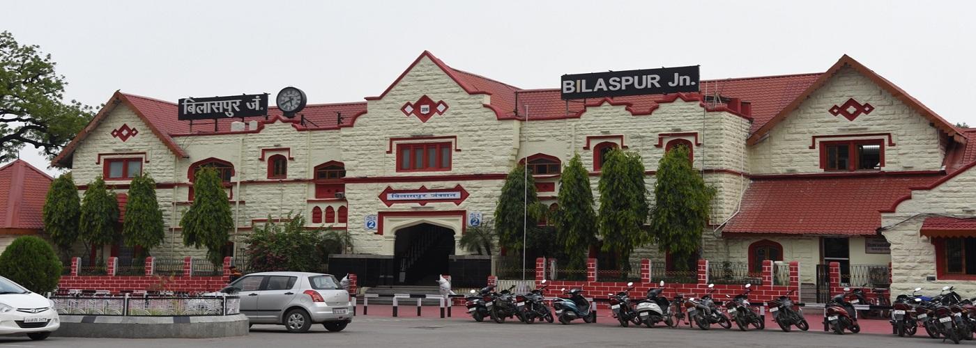
Bilaspur railway station is located at a distance of 25kms on the Bombay- Howrah main line.
Air
Raipur (141kms) is the nearest airport well connected to Mumbai, Delhi, Nagpur, Bhubaneswar, Kolkata, Ranchi, Vishakhapatnam and Chennai.
Road
Regular busses are available on the Bilaspur to Ratanpur (25kms).